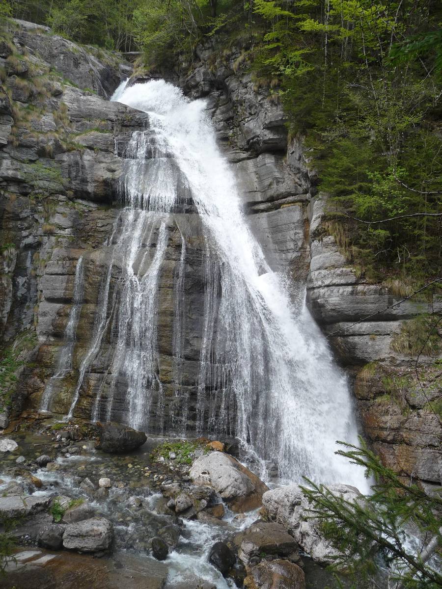
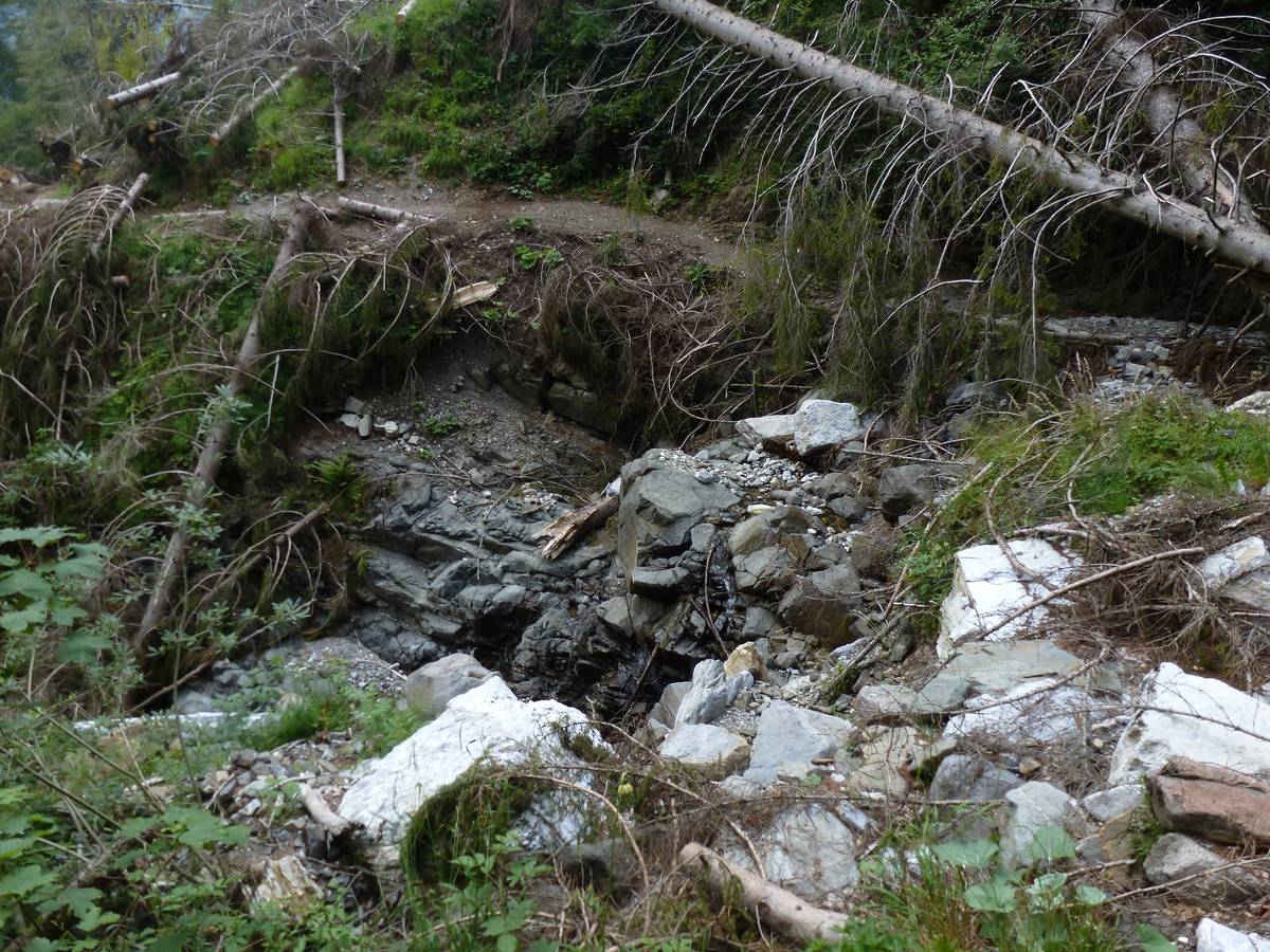
10 - Hell's Waterfall

Posted in Geological itinerary of San Lucano Valley

10 Hell's Waterfall (1020 m a.s.l.) - Agordo Formation and Voltago Conglomerate

There is a long outcrop of the Werfen Formation along the Bordina creek composed of a substantial block of layers which, in and of itself, is characterised by similar features (calcareous-marl rocks, silty-arenaceous, thinly-layered and thus easily erodible). If we took a closer look at the lithological composition and its sedimentological characteristics, however, we will notice continuous evolution. This variability has prodded the geologists into dividing the Formation into nine members in order to identify in each of them higher homogeneity (a member is a lithostratigraphic unit which is inferior in the hierarchy compared to a formation).

11 - The “U-shape” section

Posted in Geological itinerary of San Lucano Valley

11 The “U-shape” section (1088 m a.s.l.) - Panoramic view between Terza Pala and Agnèr

Slightly upstream from the crossroads between the CAI path and the military road to Pont, the visitor can admire a postcard-perfect portion of the San Lucano Valley with its quaint U-shaped profile, tucked between the Terza Pala and Agnèr. The section is 3000 metres wide and 2100 metres deep.

It has a slightly asymmetric build, its left side being steeper as its strata are running counter to the slope, whereas its right side is less inclined thanks to its dip slope strata and the landslide deposits at the base.

A picturesque view over the San Lucano Valley with its classic “U” shape is revealed just before reaching Pont; Pale di S. Lucano on the left and Agnèr on the right (Photo DG). A picturesque view over the San Lucano Valley with its classic “U” shape is revealed just before reaching Pont; Pale di S. Lucano on the left and Agnèr on the right (Photo DG).

12 - Pont

Posted in Geological itinerary of San Lucano Valley

12 Pont (1149 m a.s.l.) - The quarries and the Moena Formation

There is a beautiful waterfall carved in the Morbiac Limestones in Pont - a dark grey marly limestone with a nodular appearance deposited in the Late Anisian in shallow water environments or in marshy areas.

A stroll along the left bank of the stream will bring us to the remains of a quarry abandoned a long time ago. In the immediate post-war period, a series of small quarries, some of which located underground, supplied the “Black Taibon Marble”; it was a dark bituminous limestone of the Moena Formation. Machine remains, half-finished blocks and signs left on the stone by cutting with rotating wire are still visible in the area. The quarries emit a strong sulfur smell and there are sometimes hydrocarbons drip from the dark rock.

Thef Pon waterfall - a skip of about 30 metres carved out of Morbiac Limestone layers (photo DG).The Pont waterfall - a skip of about 30 metres carved out of Morbiac Limestone layers (photo DG).

13 - Casera Pian della Stua

Posted in Geological itinerary of San Lucano Valley

13 Pian della Stua (1373 m a.s.l.) - The transition from cliff to basin

Pian della Stua's ravaged landscape suggests that we stand on the debris of an ancient landslide, now completely covered by vegetation. The plants thrived thanks to the abundant volcanic material which are more fertile than the dolomite.

Val di Reiane is the northern slope composed of igneous rocks (andesite and reshaped pillow lava). It is streaked with gorges trending along ancient Triassic faults. The valley floor was carved in the predominantly thinly-layered limestones of the Livinallongo Formation, which are partly covered by scree and landslide particles; the alternation of layers of different erodibility has led to the creation of several waterfalls.  The valley’s southern flank is entirely carved from Schlern Dolomite and corresponds to the reef escarpment of Pale del Balcon.

Casera Pian della Stua, in the background the cliff escarpment of the Pala-Group, with Sass Negher (photo DG).Casera Pian della Stua, in the background the cliff escarpment of the Pala-Group, with Sass Negher (photo DG).

14 - Casera Campigat

Posted in Geological itinerary of San Lucano Valley

14 Casera Campigat (1801 m a.s.l.) - The cliff escarpment

Despite its rudimentary equipment, the hut (1801 metres above sea level) can provide the visitor with sufficient shelter in case of need. In the surroundings of Casera Campigat (Sass Negher, Campo Boaro, Val delle Camorze, Coston della Vena) there emerge igneous rocks (pillow lava) allowing us to observe directly their coming into contact with dolomite rocks. This is an area that abounds in various minerals quartz, analcime, heulandite, chalcedony and even native copper.

The Pass Cesurette and Casera Campigat, beyond the ridge the village of Garès appears; the twisting military road can be seen cresting towards the dairy; the path proceeds following the ridge to the right. In the foreground to the left can be identified the tectonic contact of the right transcurrent fault between the light-coloured rocks of the cliff escarpment and the dark-coloured reshaped pillow lava (photo Lucio D'Alberto).  The Pass Cesurette and Casera Campigat, beyond the ridge the village of Garès appears; the twisting military road can be seen cresting towards the dairy; the path proceeds following the ridge to the right. In the foreground to the left can be identified the tectonic contact of the right transcurrent fault between the light-coloured rocks of the cliff escarpment and the dark-coloured reshaped pillow lava (photo Lucio D'Alberto).

15 - Casera ai Doff

Posted in Geological itinerary of San Lucano Valley

15 Casera ai Doff (1878 m a.s.l.) - The Marmolada Conglomerate

A view from the path towards mountain pass Caoz and onte. Caoz (Monte Fernazza Formation), Lastei di Pape and Casera ai Doff (photo DG). A view from the path towards mountain pass Caoz and onte. Caoz (Monte Fernazza Formation), Lastei di Pape and Casera ai Doff (photo DG).

The visitor is offered a spectacular view over the Agnèr chain and the enormous glacier cirque of Val d’Angheràz from the mountain pass Caoz (1944). The tectonic impact in the shaping of the local landscape is obvious - the ravines etched into the transcurrent faults with their vertical fault planes along the ridge from Spiz d'Agnèr to Croda Granda.

16 - Malgonera

Posted in Geological itinerary of San Lucano Valley

16 Malgonera (approximately 1700 m a.s.l.) - Pillow Lavas

A stunning outcrop is visible from Malgonera along the CAI path Nr. 762, at an altitude of approx. 1700 metres above sea-level - a block of calcareous, thinly-layered strata of the Livinallongo Formation, covered by a stunning sequence of pillow lava, several hundred metres high. The outcrop highlights the relationship between volcanic activity and sedimentation.

Malga Malgonera with the cushion lava wall in the background. Above Monte Caoz carved in the Monte Fernazza FormationMalga Malgonera with the cushion lava wall in the background. Above Monte Caoz carved in the Monte Fernazza Formation

17 - Valgrande

Posted in Geological itinerary of San Lucano Valley

17 Val Grande (1340 m a.s.l.) - Malgonera's laccolith rocks

The CAI path Nr. 762 descends from Malgonera towards Pont crossing what used to be the state-owned forest of Malgonera prior to the storm Vaia, and cuts through Val Grande. Val Grande offers the possibility to discover quite rare intrusive igneous rocks, such as pyroxenite, gabbro, monzonite and syenite.  Pyroxenite is a dark-coloured rock that is very poor in silica (ultrabasic rocks), and is mainly composed of black prismatic augite pyroxenite (black prismatic) and tiny green olivine crystals. Gabbro composed in similar quantities of prismatic augite pyroxenite (black prismatic) and plagioclase with light grey in colour and glassy appearance.

Val Grande, outcrop of pyroxenites, dark-colored ultra-basic intrusive rocks (photo DGVal Grande, outcrop of pyroxenites, dark-colored ultra-basic intrusive rocks (photo DG

PROJECT PARTNERS


universitat innsbruck

UNIVERSITY OF INNSBRUCK


Logo IIS Follador

ISTITUTO DI ISTRUZIONE SUPERIORE
"U. Follador - A. De Rossi"


circolo cultura e stampa bellunese

CIRCOLO CULTURA E STAMPA BELLUNESE